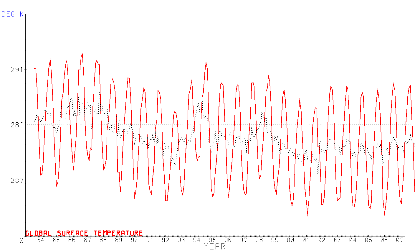
The raw data used to test predictions of the AGW hypothesis came from the NASA GISS web site. The data was assembled by the ISCCP cloud data project and is freely available for download allowing anyone to reproduce these results. This analysis doesn't attempt to discern trends, owing to the intrinsic uncertainty of detecting a trend in a highly variable set with known discontinuities. Instead, the 25 years of accumulated data is averaged and used to discern the response of the climate system to change.
The data set aggregates 3 or more radiance channels from at least 5 geosynchronous satellites and 1 polar orbiter to construct each monthly aggregate. Much of the data is continuously sampled and coalesced into 3 hour intervals, which are further aggregated into monthly averages for each time period and again into composite monthly averages. Radiance values from the dozens of satellites contributing to the data set are normalized to reference values obtained from an overlapping polar orbiting satellite, which is the mechanism used to accurately merge data from multiple satellites. The most significant discontinuities occur when the reference polar orbiting satellite is upgraded, for example as happened around 10/2001, when NOAA-14 was replaced by NOAA-16. When averaged over several years, this discontinuity appears as an anomalous temperature increase which seems to have found it's way into various temperature reconstructions, including GISSTEMP. The corrected satellite data actually shows a global temperature decrease since the early 1980's! This is another reason to be wary of anomaly analysis which can't discern between data anomalies and anomalous trends.
The satellite data includes relatively direct measurements of surface temperatures, surface reflectivity, cloud temperatures, cloud optical depth (from which cloud emissivity and reflectivity are derived), ice and snow coverage and cloud coverage. It also includes many derived values and data from other sources including atmospheric temperature and pressure profiles, water and ozone column measurements and numerous cloud related properties. Data is binned into 6598 equal area grids approximately 280 km^2. During the 25 years of data collection, there's been virtually 100% coverage of the Earth's surface with 24/7 three hour resolution. The only exceptions are at the poles during the winter months, when measurements requiring illumination can't be made. This level of coverage is unavailable in any other climate related data set and permits analysis whose results are far more accurate than can be obtained from surface measurements, proxies or reconstructions. The only processing applied to the satellite variables by this analysis, is to aggregate them into a coarser grid. The 10/2001 bias was not even removed, as it doesn't materially affect the long term, average system response. The internal grid used for energy budget calculations is comprised of six 30 degree slices of latitude, weighted by the fraction of surface area each slice represents. Calculations have been performed with slice sizes from 2.5 degrees (72 slices) up to 180 degrees (1 slice). Using 30 degree slices has been empiricly determined to be the best trade off between accuracy and calculation efficiency for this level of analysis.
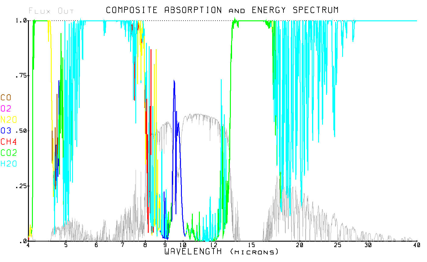
The energy balance calculations are performed in the wavelength domain, spanning .1μ to 1000μ with a logarithmic resolution of approximately 23000 wavelength buckets per decade (0.1nm @ 1μ). An example of an energy spectrum used by the calculations is shown in the next graph.
The color coding in the absorption plot indicate which greenhouse gas is responsible for the majority of the absorption in each wavelength bucket. The gray plot is one of the energy spectrums used for calculating the energy balance. The various absorption characteristics used by the analysis are calculated from the latest HITRAN absorption line data, available via anonymous ftp and satellite provided water and ozone column data from GISS, also available via anonymous ftp.
When energy calculations are performed, they are done one wavelength bucket at a time and then integrated over all wavelengths. Temperatures are represented as standard Plank energy distributions.